Category Archives: In General

Boating Tip #21: Identifying Lights

Download Boating Tip #21: Identifying Lights (PDF format, 55KB)

Many types of vessels can be identified at night by their unique light colors or patterns, which they display in addition to their sidelights and sternlight.

Vessels not under command (NUCs) display two all–round red lights. (Memory aid: Red over red, the captain is dead).

NUC under way and making way

Vessels restricted in their ability to maneuver (RAMs), display three all–round lights. The top and bottom lights are red and the middle light is white. If the vessel is restricted in her ability to maneuver because she is tending SCUBA or recreational divers, a rigid replica of the international code flag A (alpha) must also be displayed. If the vessel is engaged in underwater operations or dredging, in addition to the red–white–red all–round lights, two all–round red lights are displayed on the side of the vessel on which the obstruction exists, and two all–round green lights are displayed on the side of the vessel on which it is safe to pass. (Memory aid: Red, white, red, working ahead).

RAM with obstructions, not making way Ram underway and making way

Although highly unlikely, if you come across a vessel displaying three green all–round lights in a triangular pattern, stay away. You should not approach within 1,000 meters because the vessel is engaged in minesweeping operations. (Memory aid: Green, green, green, mines may be seen).

Minesweeper underway and making way, and heading right at you

On international waters, a power driven vessel constrained by draft displays three all–round red lights in a vertical line. (Memory aid: Rudder rubbing rocks).

CBD, under way and making way

A red all–round light displayed above a white all–round light indicates that the vessel is a commercial fishing boat engaged in fishing, while a green all–round light displayed above a white all–round light indicates the vessel is engaged in trawling and is dragging nets through the water. (Memory aid: Red over white, I’m eating fish tonight. Green over white, I’m eating shrimp tonight).

Fishing vessel anchored or
underway but not making way
Fishing vessel underway

Anchored vessels less than 50 meters in length display one all round white light. Vessels 50 to 100 meters in length display two all–round white lights, one high up at the bow, and one lower near the stern. Large vessels greater than 100 meters in length, also display two all–round white lights, but in addition are required to illuminates the decks.

Anchored vessel > 50 meters but < 100 meters in length

If the vessel is aground rather than anchored, the same white anchor lights are displayed, but in addition two all–round red lights are displayed, indicating the vessel is not under command.

Vessel aground < 50 meters in length Vessel aground > 50 meters in length

A pilot vessel while engaged in piloting duties, displays a white all–round light over a red all–round light. (Memory aid: White over red, the pilot’s ahead).

Pilot vessel while on pilotage duty

Hovercraft or air–cushioned vessels while in the non displacement mode, display a yellow all–round light which flashes at a rate of 120 flashes per minute. (Memory aid: Flash yellow when hovering).

Hovercraft in non displacement mode

Law enforcement vessels may display a flashing blue light. (Memory aid: Flash blue when chasing).

Law enforcement vessel

Sailboats display running lights only (sidelights and a sternlight) rather than steaming lights. If the sailboat is less than 20 meters long, a red, green and white tri–light may be carried on top of the mast instead of the sidelights and a sternlight. Or instead, a sailboat can display sidelights, a stern light, and a red all–round light over a green all–round light on top of the mast. If a sailboat is operating under auxiliary power, steaming lights should be displayed, and if applicable, the red and green all–round lights should be turned off. (Memory aid: Red over green, I’m a sailing machine).

Sailboat dead ahead Sailboat with optional all–round lights

Small sailboats less than 7 meters (23 feet) in length, or boats being propelled by oars may display sailboat running lights, but are only required to have a white flashlight or lantern aboard, which can be turned on in enough time to prevent a collision.

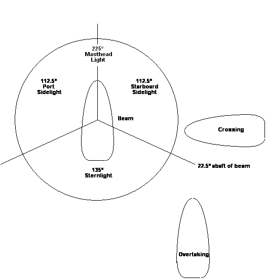
Unencumbered power driven vessels or powerboats which are not restricted in their ability to maneuver, NUCs, constrained by draft, engaged in fishing, trawling, or towing; display 112.5° sidelights, a 135° sternlight and 225° masthead light. If the vessel is greater than or equal to 50 meters in length, two masthead lights are displayed, and the forward masthead light is lower than the aft masthead light.

Powerboat < 50 meters in length Powerboat > 50 meters in length

A power driven vessel greater than 7 meters but less than 12 meters in length displays sidelights and may display an all–round white light instead of a masthead light and sternlight. Small powerboats less than 7 meters in length and not capable of moving at speeds greater than 7 knots, may display sidelights and a sternlight, but are only required to display an all–round white light.

Small powerboat < 7 meters in length capable of < 7 knots

An intermittent yellow light flashing three times, followed by three seconds of darkness, followed by another three flashes of yellow light indicates a submarine on the surface. (Memory aid: Yellow sub on surface, hide and seek).

There are numerous rules concerning lights for tugs and their tows depending on size of the tug (towing vessel), the length of the tow, and whether the tow is being pulled astern, towed along side, being pushed ahead, inconspicuous or partially submerged, and whether on inland or international waters.

On international and inland waters, the tug pushing ahead or alongside, or pulling a tow whose stern is less than 200 meters behind the stern of the tug, displays two white 225° masthead lights in a vertical line. If the stern of the tow is greater than 200 meters behind the stern of the tug, then three masthead lights are displayed. A tug towing astern will also display a yellow 135° sternlight above a 135° white sternlight. (Memory aid: Yellow over white, my towing hawser is tight).

Tug with tow > 200 meters astern

On inland waters only, a tow being pushed ahead or towed alongside will display a special flashing 180° – 225° yellow light on the bow of the tow which flashes 50 – 70 times per minute, and the tug will display two 135° yellow sternlights and no white sternlight. (Memory aid: Inland tug is touching the tow, two yellow lights will show).

Small recreational vessels not normally engaged in towing operations, but providing emergency towing assistance to another boater in distress, are not required to display towing lights. However, they must alert other vessels to the fact that they are towing another vessel by illuminating the towline.

Boating Tip #20: Dayshapes

Download Boating Tip #20: Dayshapes (PDF format, 22KB)

Shapes are displayed during daylight hours in lieu of lights which are displayed from sunset to sunrise or in restricted visibility. The three dimensional shapes are raised aloft high in the rigging to indicate the type of vessel or an activity in which the vessel is engaged. The shapes are always black in color. On large vessels > 20 meters (65’7″) in length, the shapes have a diameter of at least 0.6 meters (approximately 2 feet), and when multiple shapes are displayed, they are separated by at least 1.5 meters (approximately 5 feet) of vertical space. On shorter boats, the shapes can be smaller in size. The two dayshapes most often displayed by recreational vessels, are the black sphere and the black cone. The black spherical shape indicates that a vessel is anchored. The black conical shape, pointed downwards is displayed by a sailboat while under power during daylight hours.

Boating Tip #18: Aids to Navigation

Download Boating Tip #18: Aids to Navigation (PDF format, 222KB)

Aids to navigation include fixed beacons or day marks. They include floating buoys, which can be pillar, spar, spherical or barrel shaped, cone shaped nuns or cylindrical cans. They can be used as lateral marks, mid channel marks, preferred channel marks where there are junctions and bifurcations, safe water marks, isolated danger marks, special marks, information and regulatory marks, and ranges. Some aids to navigation are lit, including lighted buoys, lighthouses, light ships, and LNBs (large navigational buoys).

Buoys
Buoys consist of a float, mooring chain and anchor. They may be equipped with lights and/or sound signals such as bells, gongs, or whistles.

In the Lateral System used in the U.S. and in IALA region B, which includes all of the Americas, the numbers on buoys increase as you head in from the sea (except on Western Rivers and the Intracoastal Waterway).

Beacons
Fixed beacons are usually erected in shallow water or on breakwalls. They are more reliable than buoys because they don’t move. Their colors match buoys that would be placed in the same locations.
Lights
Lights used as navigational aids include lighted buoys, lighted beacons, lighted superbuoys, lighted offshore platforms, lightships, and lighthouses. Lights have distinguishing colors, characteristics, and periods. Light colors are usually red, green, white, or yellow. Period of a light is the time in seconds that it takes to complete a light cycle. Elevations of lights are indicated on charts and in light lists. The nominal range of a light, or how far the light can be seen in clear weather, is also charted.

Some lights, called directional lights, have sectors. White light is used to indicate safe passage areas. Colored glass panels may be used to obscure or shield a sector of light or show light in another color (usually red to indicate danger areas).

Light Characteristics
Fixed Always on
Occulting Duration of light is longer than the duration of darkness
Isophase Equal duration of light and darkness
Flashing Duration of light is shorter than duration of darkness
Quick 50 – 79 flashes per minute
Very quick 80 – 159 flashes per minute
Ultra quick 160 or more flashes per minute
Starboard Side Aids
Red buoys are found on the starboard side of a channel when entering from seaward and can be lighted buoys, nuns, or triangular daymarks. Red buoys are always evenly numbered. Red buoys, if lit, have red or white lights, and the light pattern can be fixed, flashing, occulting, quick–flashing, or of equal intervals. Use the memory aid “Red Right Returning” to help you remember to keep red buoys on your starboard side when entering from seaward.

Port Side Aids
Green buoys are found on the port side of a channel when entering from seaward and can be lighted buoys, cans, or square daymarks. Green buoys are always odd numbered. Green buoys, if lit, have green lights, and the light pattern can be fixed, flashing (which is the most common), occulting, quick–flashing, or of equal intervals. Under the old buoyage system used before 1989, green buoys were black, and if lit, were lit with white lights.

Horizontally Striped Aids
Horizontally striped aids are also known as preferred channel marks. They have red and green horizontal bands that mark junctions, bifurcations, or obstructions that can be passed safely on either side. Junctions come together and bifurcations split. The preferred channel is to starboard when entering from seaward if the top band is green, and to port if the top band is red. The buoys can be lighted buoys, cans or square daymarks if the topmost band is green, or lighted buoys, nuns or triangular daymarks if the top band is red. The light pattern is composite group flashing (2 + 1).

Vertically Striped Aids
Vertically striped aids mark safe water. They are red and white vertically striped. They are not numbered, but may be lettered. They can be sphere shaped buoys, lighted and / or sound buoys, octagonal shaped marks. They are usually located in the middle of a channel. If lit, they have a white light which flashes a distinctive Morse code A (dot dash, dot dash, dot dash).

Special Marks
Special marks are yellow colored buoys, daymarks, cans or nuns. They are used to mark anchorages, military exercise areas, scientific data collection areas, traffic separation schemes, cables, diving areas, or other areas of special interest. Special marks are lettered rather than numbered, and if lit, have yellow lights which have a fixed or flashing characteristic.

Isolated Dangers
Isolated danger buoys or marks identify hazards. They are horizontally banded – black, red, black, and have two black, spherical topmarks placed one on top of each other. They are not numbered, but may be lettered. They have white lights and their light characteristic is Fl (2) 5 sec or two flashes then an eclipse period of 5 seconds.

Information and Regulatory Markers
Information and regulatory markers provide information, instructions, notify boaters of dangers, and mark areas with special regulations, restrictions or which are off–limits. They are often used to indicate swimming areas, or to inform boaters that they are entering an area where speed limits are enforced. They are white in color with orange markings. For instance, white buoys with orange crossed diamonds indicate exclusion areas. White buoys with orange open diamonds indicate danger areas. White buoys with orange crossed circles indicate restricted operations. If lit, information and regulatory markers have white lights, and may use any rhythm except flashing or quick flashing.

Boating Tip #17: Determining Set & Drift

Download Boating Tip #17: Determining Set & Drift (PDF format, 23KB)

To find set (direction of the current) and drift (speed of the current), compare your intended course with the course made good.

Plot your starting position and indicate the time. Draw the track line, correcting for true bearing if necessary. Use 60 D St to find the distance down the track line where you should be at the time of your 2nd fix (your DR plot). Plot your 2nd fix. Find direction from the DR to the 2nd fix. This is the set. Measure distance from the DR to the 2nd fix. Use 60 D ST to find speed. This is the drift.

Example: Determining Set & Drift

You depart from the Isthmus on Santa Catalina Island at 1245 enroute to Newport Harbor. Your vessel’s speed is 9.4 knots. At 1400, your vessel’s position is 33° 27.6′ N, 118° 17.4′ W. What was the set and drift?

Boating Tip #16: Set & Drift

Download Boating Tip #16: Set & Drift (PDF format, 23KB)

Currents cause a discrepancy between your actual position and your predicted position. In addition to current, the wind, fluctuations in engine speed, your skill in steering a straight course and concentration at the helm cause you to deviate from your intended course. The longer your trip, the stronger the current, the farther off course you will be.

You can determine the course you need to steer to compensate for a known set (direction of the current) and drift (speed of the current). Plot your starting position, point A, and draw your track line. Plot the direction of the current (set) starting from point A. Using your dividers, measure a distance equal to 1 hour of current (drift) starting at point A down the set line. Mark the point where the dividers touch the set line as B. Measure a distance equal to 1 hour of boat speed with your dividers. Place one leg of your dividers on point B on the set line, and the other leg of the dividers on the track line. Mark the point on the track line as point C. Draw a line to connect points B and C, and find the course. This is the true course to steer to compensate for set and drift.

Example: Determining Course to Steer for a Known Set and Drift

Your position at 0700 is 32° 53′ N, 117° 28′ W. The current is 162° at 2 knots. Your course is 126° true and your speed is 6.3 knots. What compass course must you steer to correct for the current (set and drift) and stay on course for your destination?

Boating Tip #15: Speed Made Good

Download Boating Tip #15: Speed Made Good (PDF format, 21KB)

Speed over ground is speed made good, or the vessel’s actual speed found by dividing the distance between two fixes by the elapsed time interval between the taking of the two fixes.

Plot your starting point and ending position on a chart and measure the distance between the two points. Calculate the time interval from start to finish by subtracting the starting time from the ending time. Use 60 D Street and solve for speed using the two fixes and the time interval. You don’t need to know course or the vessel’s speed through the water in order to find speed made good.

Example: Speed Made Good

At 1350 you are at position 32° 34.8′ N, 117° 24.4′ W on a compass course of 018° at a speed of 5.2 knots. At 1620, you are at the entrance to the Mission Bay Channel. What was the speed made good?

Boating Tip #14: Course Made Good

Download Boating Tip #14: Course Made Good (PDF format, 21KB)

Your course made good is your actual track, or your direction from your point of departure to point of arrival. Always plot your true course, not your magnetic course or compass course, on the chart.

Start by plotting your starting and ending points on the chart. Draw a line between the two points. Determine the direction from the starting point toward the ending point, either easterly or westerly. Use your plotter and triangle (or compass rose) to find your true course in degrees. Course made good is always a true bearing.

Example: Course Made Good

You depart from a position 3 miles directly west of Batiquitos Lagoon at a speed of 6 knots. Forty–five minutes later, you are at position 33° 09.5′ N, 117° 25.9′ W and stop to fish. What was the course made good?

You don’t need to know speed, time, distance or heading in order to find the course made good. This was just extraneous information.


Boating Tip #13: 60 D Street

Download Boating Tip #13: 60 D Street (PDF format, 32KB)

Determining Speed · Determining Time · Determining Distance

A 60 D Street calculation is used to find speed, distance or time when two of the three factors are known. Place known values in the appropriate quadrants. Multiply across quadrants. Divide the product of the numbers in the upper quadrants by the product of the number in the lower quadrants, or vise versa.

Speed = (60 x Distance) / Time
Distance = (Speed x Time) / 60
Time = (60 x Distance) / Speed

Examples: Finding Distance

Cruising at 6.3 knots, it took 7:05 to cross the Outer Santa Barbara Passage from Cat Harbor (Santa Catalina Island) to Pyramid Cove (San Clemente Island). What was the distance?

You got underway at 0635 at a speed of 7.2 knots, and arrived at your destination at 1715. How far did you travel?

Examples: Finding Speed

It took 55 minutes to travel 6 nautical miles from Mission Bay to the LaJolla kelp beds. What was your speed?

You depart from Avalon at 0800 and must travel 72 nautical miles back to your marina at Shelter Island in San Diego Bay. You want to arrive before sunset at 2015. What speed must be made?

Examples: Finding Time

Your vessel’s top speed is 6.3 knots. You plan to sail a total distance of 275 nautical miles during your upcoming trip. How many hours will you be underway?

The distance from Dana Point to Avalon is 33 miles. Your vessel’s average speed is 8.1 knots. How long will the trip take?

Boating Tip #12: Time Conversions

Download Boating Tip #12: Time Conversions (PDF format, 27KB)

When performing navigation problems using time, use the military time, 24–hour clock. For example 1:00 am is written as 0100, and 1:00 pm is written as 1300. When solving 60 D Street problems, always use time in minutes.

Converting Time

When converting time in hours and minutes to minutes, multiply the number of hours by 60 and then add the minutes.

Change hours into minutes
3:42 = (3 x 60) + 42 = 222 minutes

When converting time in minutes to hours and minutes, divide minutes by 60 to obtain hours. Multiply the quotient by 60 and subtract from the dividend (minutes). The remainder is the minutes. For example, to convert 3:42 into minutes, and conversely, to convert 222 minutes to hours and minutes.

Change minutes into hours and minutes

Determining Elapsed Time

To determine elapsed time, use military time. Subtract the starting time (time of departure) from ending time (time of arrival). If you “borrow” an hour, add 60 minutes.

For example, you left from your marina at 3:42 pm (1542 hours) and arrived at your destination at 8:13 pm (2013). How long did the trip take?

Example:
You spotted Anacapa’s West Island at 0740 after sailing all night from Newport Beach. You departed from Newport at 1510. How long were you underway?

Estimated Time of Arrival

Plot your point of departure or your current starting position (point A) and your destination (point B). Draw a line between the two points, and measure the distance with your dividers and the latitude scale. Find your boat speed from your knotmeter or GPS. Enter speed and distance and use the 60 D Street calculation to solve for time and determine how long the trip will take. Convert time in minutes to hours and minutes, and add to your time of departure.

For example, your 0900 position is off La Jolla at 32° 50′ N, 117° 20′ W and you are enroute to Dana Point at a speed of 6.2 knots. What is your estimated time of arrival?