
Boating Tip #1: GPS
Download Boating Tip #1: GPS (PDF format, 123KB)
The Global Positioning System has revolutionized marine navigation. A GPS receiver is a marine electronic device that will provide your exact position and help you navigate to your destination. The 24 satellites orbiting earth will give you an accurate fix on your location on the water anywhere on earth, any time of the day or night, and in any kind of weather. It is the most advanced navigation system ever to exist.
The Global Positioning System was conceived in 1960. It is a consolidation of navigation projects, started by the U.S. Air Force but joined by other military branches in 1974. The project was named NAVSTAR Global Positioning System, but is commonly called GPS. It cost $10 billion to develop, and only became fully operational in April 1995. The project is monitored and administered by the U.S. Department of Defense.
GPS is a satellite navigation system. A constellation of 24 satellites, each orbiting 12,552 miles above the earth, circle the globe twice a day / once every 12 hours, and beam radio signals toward earth. Satellites send a sequence of numbers not repeated for a millisecond that enable GPS receivers to measure distance from each satellite. Every GPS receiver has the same sequence stored in its memory and knows the exact time the satellite started sending the numbers, and time segments for radio waves to get from the satellite to the receiver. This technique is called ranging. Each satellite knows its own position and the position of all the other satellites and sends the orbital information to the receiver.
What a GPS Can Do
A GPS calculates your present position using a mathematical process called triangulation. It can lead you to a specific position, store a position in memory so you can return at a later time, help you find a favorite fishing or diving spot, and get you back home to your marina. It can retrace a route –– like leaving a breadcrumb trail. And, today a GPS can be interfaced with other marine electronics and share data as part of an integrated navigation system.
GPS Receiver
A GPS receiver is a small, portable, electronic device used to pick up signals from satellites. It is used in conjunction with a chart and compass, and/or chartplotter. Finding position by GPS is done by triangulation, using intersecting spheres to determine latitude, longitude and altitude. In order to get 3 dimensions, the GPS receiver needs to lock onto 4 satellites. The 4th satellite synchronizes time between the satellite’s atomic clocks and the receiver’s quartz clock.
You will never get a busy signal. GPS receivers only listen to satellite transmissions but do not interact, so the number of simultaneous users is unlimited.
Desirable Features of a GPS Receiver
When purchasing a GPS, look for a ruggedly constructed receiver which is waterproof, because it is bound to get wet in a marine environment. Buy a receiver that floats in case you drop it overboard. A large screen will make it easier to read and a friendly interface will help you learn to use the many features. The unit should have a long battery life so you don’t have to carry spare batteries on day sails. The receiver should also be designed to operate with multiple power source options –– batteries, AC and DC external power, since batteries can get expensive, and not all boats have an inverter. And, the receiver should be WAAS enabled for increased accuracy.
GPS Manufacturers
| Furuno | (360) 834–9300 | www.furunousa.com |
| Garmin | (913) 397–8200 | www.garmin.com |
| JRC | (206) 654–5644 | www.jrcamerica.com |
| Magellan | (800) 669–4477 | www.magellangps.com |
| Northstar | (800) 628–4487 | www.northstarmc.com |
| Raymarine | (603) 881–5200 | www.raymarine.com |
| Simrad | (425) 778–8821 | www.simradusa.com |
| Si–Tex | (727) 576–5734 | www.si-tex.com |
Concerns About Reliability
The concern that the Department of Defense could turn off GPS codes for civilian receivers in time of war, is unfounded. It is extremely unlikely that GPS would be turned off because so many industries (airlines, maritime industry, shipping, trucking, as well the military) now depend on GPS for day to day operation. It is much more likely that your GPS won’t work because the batteries go dead, you drop it, or it gets wet.
GPS Accuracy
The accuracy of GPS is somewhere between 1 and 15 meters (3.3′ – 49.2′). There was a concern about enemies of the U.S. using GPS against us, so two tiers of accuracy were originally developed. In May 2000, President Clinton eliminated Selective Availability which limited accuracy to civilian receivers, making civilian receivers much more accurate.
There have been continual attempts to improve GPS accuracy. Methods such as Satellite Differential GPS were developed. The newest system to improve accuracy, integrity and availability of GPS signals over standard GPS receivers is called WAAS. WAAS does not need to use an external DGPS beacon receiver.
Actually 3 separate systems have been developed: WAAS, EGNOS and MSAS. WAAS, the Wide Area Augmentation system was developed in the U.S. by the Federal Aviation Administration. EGNOS, the European Geostationary Navigation Overlay System was developed by a consortium of European companies and organizations. And, MSAS, the MTSTAT Satellite Based Augmentation System was developed in Japan by the Japan Civil Aviation Bureau.
The WAAS network operates with existing GPS satellites. The coverage area includes the U.S. (except parts of Alaska), Mexico, Central America, and much of Canada. Ground reference stations are located at known positions across the U.S. Ground reference stations continually receive data from GPS satellites, then transmit data to master stations located on the East and West coasts of the U.S. The master stations calculate error and generate correct data, then send corrected differential signals to two geostationary satellites in orbit above the equator. The geostationary satellites transmit the corrected data on the standard GPS frequency. WAAS enabled GPS receivers then receive the corrected data with an accuracy of typically less than 3 meters (10 feet).
GPS Limitations
Regardless of how reliable or accurate a GPS is, you should not depend on GPS as a single method of navigation. You should always have a back–up and should verify measurements from other navigational methods. Use good judgment and caution. Refer to the official government issued, NOAA paper chart to make sure your track does not take you across land masses or other obstructions. Keep a written log and DR on a paper chart so you have a back–up if the electronic instruments fail.
Atmospheric interference can reduce GPS accuracy. Satellite geometry or position in the sky relative to your position, and reflected or multi–path signals can also reduce a receiver’s accuracy. Typically, altitude accuracy is not as good as horizontal position accuracy, but this is of little concern to the mariner.
A GPS receiver may not work when you need it most. Signals can be blocked. For example, radio signals cannot penetrate buildings, landforms, dense vegetation, rocks, or caves. Remote areas may not be covered by the minimum number of satellites to get a fix. Signals may be too weak, or broken up. A GPS receiver antenna may not be not sensitive enough to pick up the satellites. Batteries can go dead.
Initializing the Receiver
The GPS antenna must be open to the outside to receive a signal. External antennas (usually more sensitive than internal antennas) are required if the GPS receiver is inside an enclosure like a boat. However, receivers can detect satellite signals through plastic bags, windows, and canvas.
To turn on a GPS receiver, move outdoors to an area free of obstructions. Put fresh batteries in the GPS receiver or make sure that rechargeable batteries are fully charged. Press and hold the power button to turn the unit on. The power button usually looks like a light bulb. A warning will appear reminding you not to depend solely on the GPS, along with a note that satellites are being acquired. Press the page button to acknowledge that you’ve read the warning. The initialization process is automatic. While initializing, the info page will be displayed showing signal strength bars and the location of satellites currently above the horizon. Signal strength bars will tell you if you need to move in order to get better reception.
When turned on the first time or after being moved more than 300 miles, receivers download an almanac of orbital information of all the satellites. Each satellite has the information for all the satellites. The time it takes to do this is called TTFF or Time To First Fix. TTFF may take up to 10 minutes. After TTFF, the almanac is stored in the receiver’s memory, and locking in takes less time (usually less than 1 minute).
Buttons / Interface Keys
A GPS receiver has several buttons or interface keys which enable you to make selections or enter data. Unfortunately, different manufacturers have chosen to give the keys different names. Typically though the following keys are included.
- Power
- Turns the receiver on or off
Turns the backlighting on when the unit is already on - Menu
- Used to display page options
When pressed twice, displays the main menu - Enter
- Select or confirm an option
When held, selects the current location as a waypoint - Quit
- Ends an operation in progress
Cycles through pages in reverse order - Page
- Allows you to move between the different page options: info, map, pointer, highway, active route
Backs you out of a page - Nav
- Used to start or stop navigation
When held, stores current location for MOB - Zoom In
- Zooms in on the map page and decreases scale so a smaller area can be seen in greater detail
- Zoom Out
- Zooms out on the map page and increases scale so a larger area can be seen
- Rocker Key
- Controls up/down and right/left movement of the cursor
Used for data entry to cycle through alphabet, numbers, symbols – similar to a video game
Customizing Your GPS
Every GPS receiver has a set–up menu which will allow you to customize your receiver. To get to the main menu, press the menu button twice. Use the rocker key to highlight the set up menu and press enter. Customize your GPS by selecting items using the rocker key and enter button. For example, select English as the language. Choose a time format (12 hour or military time), select the time zone and whether time should be corrected for daylight savings time. Turn on the backlight timer. Set the current date and time. Select the units of measurement you want to use (feet, fathoms, meters). Choose whether distances and speed will be displayed in nautical, statute or metric units of measurement. Select whether temperature will be displayed in Fahrenheit or Celsius. Set alarms. Choose to have the coordinate format display in latitude and longitude and degrees, minutes and tenths of a minute. And select datums.
Datums are mathematical models which cartographers use to transfer coordinates from a spherical earth to a flat map. Charts are drawn so every point is known from a standard reference point or datum. A chart can have only one datum. The most common datum for use by GPS receivers are: , North American Datum 1927 (NAD 27), or World Geodetic System 1984 (WGS 84). Your receiver must be set to the correct datum before entering data.
All GPS units operate on UTC (Universal Coordinated Time) –– AKA: Greenwich Mean Time, Zulu Time. If you want the GPS to display local time, you must input an offset or difference from UTC in the setup menu. Local time is ahead or behind UTC depending on where you are in relation to Greenwich, England. Subtract from UTC if you are west of Greenwich. California is in the Pacific Time Zone (minus 8 hours from UTC, and minus 7 hours during Pacific Daylight Savings Time).
Data screens can be backlit so the receiver can be read in the dark. However, backlighting uses a lot of power and should be used judiciously. To turn on backlighting, press and release the power button. Backlighting turns off to conserve battery power after a set amount of time. Use the rocker key to adjust lighting and contrast to make the screen easier to see in existing light conditions.
GPS Page Options
Every GPS receiver has several page options which allow you to select how the data is viewed. Again, different manufacturers have chosen to include different page options. Typically though, the following page options are included: GPS information page, map page, pointer page, highway page, active route page, and the main menu.
- Info Page
- After the GPS receiver is locked into the satellites and the almanac data has been obtained, the info (or position) page is displayed. The info page will usually display: coordinates (latitude, longitude and altitude) using the position grid you select, speed, accuracy of the fix, and the date and time.
- Map Page
- The map page displays your position over a map background. It visually shows the waypoints, and track lines at different scales. Modern chartplotting GPS receivers have a built–in base map of North America which allows you to get a birds–eye view of: cities, highways, freeway exits, railroads, lakes and rivers, and coastlines. You can add much more detail by downloading information from a MapSource CD.
Press and hold the zoom out button to see a larger area. Press and hold the zoom in button to see a smaller area close–up. Press the menu button to get options, set up maps, change data fields, or show more or less information on screen.
To measure distance between any two points: highlight and select “measure distance” from the menu screen. Press enter to select point A. Use the rocker key to move to another point –– point B. Bearing and distance from point A to point B will be displayed. - Pointer Page
- The pointer page is best for use when a straight line course can not be followed. The compass ring will rotate as you change direction. The arrow will always point toward the waypoint. When you are directly on course, the arrow will be aligned with the vertical line in the compass ring.
- Compass
- A GPS cannot measure distance or direction if you are sitting still, it can only measure direction of movement. Most receivers are not electronic compasses.
- Highway Page
- The highway page is best for use when a straight line course can be followed. To navigate, follow the road. If the highway moves right, turn right until the triangle aligns with the white line in the middle of the road and points forward. Press the menu key to get highway options, change data fields or type of data displayed. Select an option, highlight and then press enter.
- Active Route
- The active route page shows the waypoints that are currently being used in the route you are navigating. The distance of each leg of the route is displayed along with the total distance of the route.
- Main Menu Page
- You can access the main menu page by pressing the menu button twice. Toggle the rocker key to select an item, then press enter. The main menu includes: a trip computer, tracks, waypoint list, route list, waypoints in close proximity to where you are, celestial information (times of sunrise and sunset, tidal information, and phases of the moon), MapSource Info, System Info, and setup options.
Marine Cartography – GPS Computer Interface
A GPS can be connected to a personal computer to add capabilities and used with digitized map databases stored on CD–ROM. GPS communicates with a computer through an input/output port and cable using NMEA standards (National Marine Electronics Association). The GPS receives your position and sends the coordinates to the computer. The computer then displays information on digitized charts on the monitor. As you move, the chart shows and updates your position. You can print out a paper copy of any chart, and you can plot your trip ahead of time on the computer and transfer the data to your GPS.
Marine Cartography – Chartplotters
Chartplotters are integrated units which display information from a GPS in chart format. They allow you to see the position of your vessel on a chart. Chartplotters allow you to place, edit and go to waypoints; create, save and follow routes, and display the vessel track. You can measure distances and bearings on the screen. You can set various alarms and timers. The MOB feature allows you to navigate back to a person or object. Chartplotters automatically log your position at a set interval.
Marine Cartography – Chart Page
Some portable GPS receivers have permanent charts stored in memory. The GPS receiver can also be connected to a PC using a serial port PC interface cable to add capabilities, upload or download data. Software must be purchased which is compatible with the receiver.
GPS Functions
- Waypoints
- Coordinates that mark a specific location or landmarks you might want to return to or travel past. Waypoints can be given a short letter/number name, or will be automatically named. You can always change the name later. Waypoints can be stored in memory which is not lost when the GPS receiver is turned off or the batteries are dead.
- Goto Function
- Goto is a function that helps you find the coordinates of a particular location. Waypoints can tell the receiver to guide you, using a steering screen, to a location. The display can tell you if you are off course, your speed over ground, how far you are off course, and your ETA.
- Routes
- A route is a list of two or more waypoints that describe the path you need to travel in the order you must follow to get from one point to another. Routes lead you to your location sequentially. Waypoints have to already be in the receiver’s memory and you have to list them in the order they need to be traveled. Another feature is automatic route reversal, which allows you to follow the waypoints in a reverse order.
- Track Logs
- Coordinates can be logged manually any time you change direction or at a specified period of time. A track log is created and stored automatically whenever you are moving. Track logs allow you to see where you have been.
- Track Back
- To reverse a track, press the menu button twice to display the main menu page. Use the rocker key to toggle to tracks and press enter. Clear the old tracks. Press the nav button, highlight track and press enter. Highlight the specific track and press enter. Highlight track back and press enter.
- MOB
- The Man Over Board feature is used to quickly mark a point for return. When the MOB button is pressed, the GPS immediately records your present position and directs you back using the navigation screen. If a person or object falls overboard, press the MOB button immediately to mark the location. The GPS will go into the goto mode and give directions back to the spot where the MOB button was pressed. This will help you to quickly locate a man overboard.
Navigation Statistics
A GPS can compile various navigation statistics which provide useful information to the mariner. Navigation information which is usually provided includes:

- Bearing
- Angular direction from north, from your present position to your destination
- Track
- A straight line course from your present position to your destination
- Course over ground (COG)
- Direction of actual movement
- Course made good
- Course you actually covered during a time interval
- Course to steer
- Best course to steer to get to the waypoint
- Cross track error (XTE)
- Distance you are off course left or right of the desired course line = your course deviation
- Elapsed time
- Amount of time that has passed since the start of your trip
- Estimated time of arrival (ETA)
- Time when you should arrive at your destination, given your current speed over ground
- Heading
- Course you are steering
- Range
- Distance from present position to destination waypoint
- Speed over Ground (SOG)
- Speed at which you actually traveled. Average and maximum speed achieved are also recorded
- Variation
- Difference between true and magnetic north
- Velocity Made Good (VMG)
- Speed at which you are approaching the destination waypoint, or speed between any two waypoints
Waypoints
To store your present position as a waypoint, press and hold down the enter key. A box will open and ask if you want to save the present position as a waypoint. Press enter to say OK and add your position to the waypoint list.
To create a waypoint manually, press and hold the enter key to get to the make waypoint page. Select a symbol. Press the rocker key to highlight the symbol field and press enter. Highlight the desired symbol and press enter.
Name or rename the waypoint, by pressing the rocker key to highlight the waypoint name field and press enter. Press the left rocker key to clear the name field. Press the up or down rocker keys to scroll through the alphabet, numbers and symbols. Press the right rocker key to move to the next space then select the next letter, number or symbol. Press enter when finished.
To input coordinates, press the rocker key to highlight the coordinate field and press enter. Press the up or down rocker keys to scroll through the numbers. Press the right rocker key to move to the next space. Select the next number until the correct latitude is entered. Repeat with longitude. When everything on the page is correct, press enter.
To go to a waypoint, press the nav key. Highlight goto point. Highlight waypoints and press enter. Highlight the specific waypoint you want to go to and press enter. The waypoint page appears. Press enter again and the pointer page appears and the distance to the destination waypoint and speed are displayed. Navigate to the waypoint by traveling in the direction the arrow is pointing until the arrow points to the top of the compass ring. If the arrow points left, go left. If the arrow points right, go right. When the arrow is pointing straight up, you are moving toward the waypoint in a straight line. When you get close to the waypoint, the receiver will give you an arriving message.
Routes
To create a route, press the menu key twice to display the main menu page. Use the rocker key to toggle to route and press enter. Highlight new, then press enter. Add two or more waypoints to make a route, then press enter.
To navigate a route, press the menu key twice to display the main menu page. Use the rocker key to toggle to route and press enter. Highlight the desired route and press enter. When you arrive at a waypoint, the GPS will move automatically to the next waypoint until you reach your destination.
How To Find Your Present Position using a GPS and Plot It On a Chart
Obtain the fix from the GPS info page. Plot the location on the paper chart. Indicate that the fix was obtained from an electronic navigation instrument by placing a triangle around the point. Draw your dead (deduced) reckoning track – Line showing the route you plan to follow to get from point A to point B. Always start a DR track at a known point (fix) and plot your position every hour. Mark your position on the DR track as a dot inside a triangle to indicate that the location was charted from an electronic fix. Connect the dots.
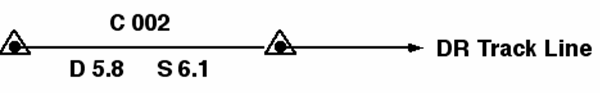
Write your course above the DR line (C 002). Use your dividers and the latitude scale to measure the leg (1 minute of latitude equals 1 nautical mile). Write the distance of the leg below the DR line (D 5.8). Determine and write speed on the chart below the DR line next to distance (S 6.1).